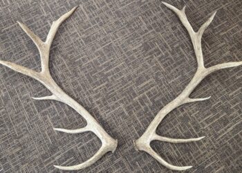
Blizzard Warning
...BLIZZARD WARNING CONTINUES OVERNIGHT FOR SNOWFALL RATES OF 1 TO 2 INCHES PER HOUR ALONG WITH WIND GUSTS OF 30 TO 40 MPH... .Heavy snow will continue for a few more hours tonight, and then start to taper off toward morning. The main concern with this storm is the intense snowfall rates of 1 to 2 inches per hour, along with strong northerly winds. This will lead to significant blowing and drifting snow, with whiteout conditions at times. A Blizzard Warning remains in effect overnight for a large area from west central and southwest Minnesota to west central Wisconsin. A Winter Storm Warning remains in effect north and south of the Blizzard Warning. ...BLIZZARD WARNING REMAINS IN EFFECT UNTIL 7 AM CDT SATURDAY... * WHAT...Blizzard conditions expected with total snow accumulations of 5 to 10 inches, with locally heavier amounts possible. Winds gusting as high as 35 mph. * WHERE...Portions of south central and southeast Minnesota and west central Wisconsin. * WHEN...Now through 7 AM CDT Saturday. * IMPACTS...Travel will be very difficult. Widespread blowing snow could significantly reduce visibility. Read more
Day | Min | Max | Summary |
---|---|---|---|
Sat, 1 Apr | 17°F | 37°F | Heavy snow (2–4 in.) and windy in the morning. |
Sun, 2 Apr | 17°F | 47°F | Mostly cloudy throughout the day. |
Mon, 3 Apr | 28°F | 45°F | Mostly cloudy throughout the day. |
Tue, 4 Apr | 29°F | 42°F | Light rain and windy starting in the afternoon. |
Wed, 5 Apr | 25°F | 47°F | Possible drizzle in the morning and afternoon. |
Thu, 6 Apr | 22°F | 42°F | Mostly cloudy throughout the day. |
Fri, 7 Apr | 26°F | 51°F | Foggy in the evening and overnight. |
Sat, 8 Apr | 22°F | 54°F | Overcast throughout the day. |